Coal mine rescue equipment | Mining rescue equipment | Mining machinery equipment


Rapid 3D Situational Awareness UAV System
- Product Description
-
Rapid 3D Situational Awareness UAV System
The system consists of UAVs, remote sensing payloads (electro-optical pods, oblique cameras, LiDAR, etc.), communication links, and a real-time modeling mobile workstation (real-time modeling software + mobile modeling computing power + field power supply). It is specially designed for disaster site combat scenarios to achieve rapid 3D real-scene modeling of disaster sites, meeting the special needs of beyond-visual-line-of-sight disaster detection and real-time data transmission to the "real-time first map" (real-time real-scene 3D model). Paired with an ultra-fast real-scene 3D browser, it supports on-site IoT perception data access, intelligent marking, 3D measurement, spatial analysis, and other functions, allowing emergency rescue command sites to see not only videos in real time but also intelligently recognize key on-site targets such as people, vehicles, buildings, roads, forests, and water bodies, accelerating the informatization of emergency rescue work, improving the timeliness and scientific nature of emergency command, and enhancing the response speed of emergency rescue.
- PH-20 Multirotor UAV
Featuring a hexacopter design, it boasts high payload capacity, long endurance, high system integration, and good reliability. The entire aircraft is mainly made of carbon fiber composite materials, which are lightweight and strong; the arms use a plug-in design for easy use and maintenance. The rotor power is installed with an inward tilt angle design, providing good flight stability, strong wind resistance, and anti-interference capability. The avionics system uses a new generation of intelligent flight control, CAN bus communication design, and sensor redundancy design, offering excellent anti-interference and expansion capabilities. It adopts advanced adaptive control algorithms and has a complete emergency guarantee mechanism to ensure safe and reliable flight.
Technical Parameters
Parameter Name Parameter Value Number of Rotors 6 Flight Platform Wheelbase 1690mm Maximum Takeoff Weight 29.8kg Maximum Payload Weight 10kg No-load Endurance Time 100min Full-load Endurance Time 50min Control Distance ≥30km Rainproof Performance Resistant to Moderate Rain Wind Resistance Level Level 8 Maximum Takeoff Altitude 5000m Operating Temperature -25℃ to +55℃ Flight Platform Deployment/Retrieval Time ≤3min 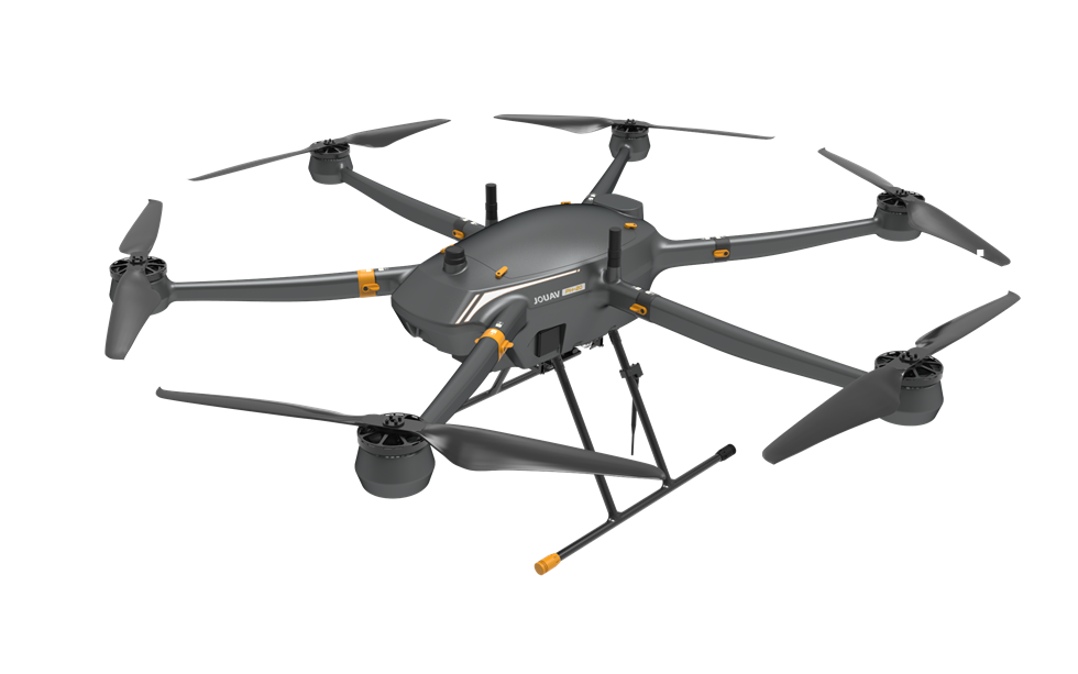
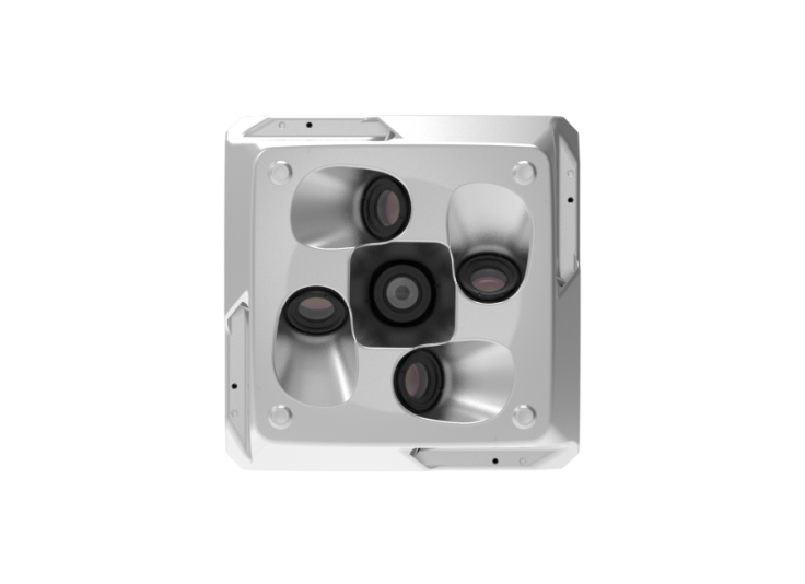
- Oblique Photography Camera: CA503R (Real-time Version)
The CA503R (Real-time Version) is a newly upgraded full-frame high-precision five-lens photogrammetric device. This device is lightweight, stable, and highly accurate. It has a built-in real-time processing module that can perform related image processing on each photo and transmit all photos back to the ground in real time through the onboard link.
Technical Parameters
Parameter Type Parameter Name Parameter Details Basic Parameters Product Weight ≤1100g Storage Capacity 1280GB*2 Sensor Parameters Total Pixels ≥220 million Number of Sensors 5PCS Optical Parameters Lens Focal Length 40mm/56mm Functional Parameters Number of Video Streams Can simultaneously output 5 camera H264 video streams Real-time Video Transmission Resolution Switchable between 4K and 1080P Real-time Photo Transmission Supports real-time transmission of photos from 5 cameras
3. Real-time Modeling Mobile Workstation
The real-time 3D reconstruction workstation consists of a real-time modeling system and a rugged high-performance computing machine. It is mainly aimed at emergency response scenarios for small-scale sudden events (natural disasters, social security incidents), providing real-time 2D and 3D data of the site, effectively implementing event early warning and on-site investigation, and quickly and accurately carrying out emergency response.
Functions:
- Real-time image stitching, allowing real-time viewing of the event area images;
- Real-time generation of digital orthophoto maps (DOM);
- Real-time 3D reconstruction to generate real-scene 3D models;
- Original image reconstruction function, progressively generating medium and high-resolution real-scene 3D models.
4. 3D Model Browsing and Analysis Software
The 3D browsing and analysis software can achieve ultra-fast loading and display of large-scale oblique photogrammetry 3D data, intelligent marking functions, 3D measurement functions, and spatial analysis functions. It assists in data viewing, display, integration, editing, and quality inspection of real-scene 3D models. It uses multi-level detail model progressive adaptive loading technology to quickly browse OSGB data of real-scene 3D models, allowing users to smoothly load large-scale real-scene 3D models even on low-end computers.
Functions:
- Intelligent marking functions for points, line segments, polygons, etc.;
- 3D measurement functions for coordinates, length and height, area, and volume;
- 3D spatial analysis functions;
- PH-20 Multirotor UAV
Keyword:
Online message
*Note: Please fill in the information accurately and keep the communication open. We will contact you as soon as possible.

Address: Hulan District, Harbin City, Heilongjiang Province, Victory Street
Contact Information:+86 400-015-0451
After-sales:+86 0451-57368359
Email:herbintianyi@163.com
1688
Official Mini Program
Official Douyin
WeChat Official Account
Online consultation
If you have any questions about the product, please feel free to contact us!